The level of the world’s oceans was unchanging for 6,000 years but has been rising at such a rate since the industrial era that almost a metre more of land will be under water by the end of the century. The sea will cover certain atolls, wash over the fertile land of deltas and flood coastal cities, driving back coastlines that are home to 40% of the global population. A direct consequence of climate change, the rapid rise in sea levels is worrying decision-makers and intriguing scientists. Some have set about surveying geological records that bear traces of variations in sea level, in search of a similar episode in the Earth’s past. We meet two geomorphologists from the universities of Bremen and Pisa who ‘read’ the coastlines as if they were books containing magic formulas to unlock the secrets of our future.

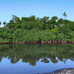
The sea has left behind innumerable traces of its passage, the tireless ebb and flow of the tides and its dominance in ancient times. Many tropical coastlines have fossilised corals a few metres above the shoreline. A hundred thousand years ago, these marine organisms were submerged beneath the ocean, like parts of the cliffs bordering the Mediterranean. The waves carved out linear ramps nine metres above the current waterline. Underwater cavities at Capo Noli in Italy bear traces of breaking waves at a time when the sea lay a few metres lower, during the Holocene. Coral reefs, marine terraces, Palaeolithic beaches swallowed up, fossilised reefs at the bottom of lagoons, sandbanks, tidemarks etched into the rock and sea caves dug out by the backwash are some of the clues about past sea levels. To work them out scientists must solve a complex equation that has been constantly changing through the ages. Nonetheless, for millions of years, it has been governed by the same variables, namely the orbital parameters of our planet, the climate, the polar ice caps and tectonic movement. “The Earth has had warmer climates in the past, and each time sea levels have risen. But the changes always happened gradually over hundreds or thousands of years”, explains Italian researcher Alessio Rovere, one of our two guides on this journey through the warm climates of the past – a journey that could well be an exploration of our near future, characterised by rising sea levels.
The vast ocean in the Age of Australopithecus
Three million years ago (Late Pliocene)
The Late Pliocene marks the beginning of a series of alternating glacial and warm interglacial cycles lasting about 40,000 years.[1] When our distant cousin, Lucy the Australopithecus, was alive, the Earth’s climate was 2 to 3 degree Celsius warmer than it is now. The continents were about 100 kilometres off their current position. The Isthmus of Panama closed up, altering the flow of the Atlantic and bringing warmer waters northwards. The atmosphere at that time contained the same amount of CO2 as it does now (about 400 parts per million), though it had accumulated over millions of years. Under the effect of climate warming, the polar ice caps shrank by up to 40%, releasing significant volumes of water. The sea level peaked at an estimated 22 metres above the current level, allowing for around a 10-metre margin of error due to the scarcity of traces left behind from that time and the difficulty of dating those that do exist.[2] It was in this vast ocean that the giant shark Megalodon lived, a powerful predator capable of attacking the whales that were evolving at that time.
Evidence
Much of the evidence of this period has eroded over time. But the island of Mallorca is home to caves with stalagmites which, several million years ago in the Pliocene, touched the surface of the sea. The higher sea level in this prehistoric era also left a light-coloured band which can be found today several kilometres inland in America. This hardened geological layer composed of fossilised beach pebbles – a palaeo-shoreline – extends down the Atlantic coast of the United States from Virginia to Florida.
“We use the Pliocene as a model because it had a similar climate to ours, not least in terms of the CO2 level, and as a prediction of our future world since that period was appreciably warmer”, says Matteo Vacchi, a geomorphologist at the University of Pisa. “Even though we need to be very cautious in drawing these comparisons, we are also interested in the Pliocene because the human impact on the climate was non-existent during that period, when the Earth was populated by a few thousand Australopithecus, which enables us to differentiate natural effects from anthropogenic pollution, which came a few million years later.”


9 Nine metres higher when Homo sapiens left Africa
125,000 years ago (Pleistocene)
The last time the climate was warmer than today was 125,000 years ago, during the last interglacial period.[1] The African lands where Homo sapiens flourished were as green and populated as our last remaining great tropical rainforests. “This period enables us to study a situation very close to our own and easier to study than the Pliocene”, explains Alessio Rovere from the University of Bremen, whose work focuses on this period.
Deep drilling in the polar ice has revealed concentrations of greenhouse gases slightly higher than pre-industrial levels (280 parts per million) in the air bubbles from these forgotten ages imprisoned in the ice sheet. The average temperature was 1.5 degrees Celsius higher and up to 5 degrees higher in Antarctica and in Greenland, which successively received exceptionally intense solar radiation in the summer due to the Earth’s orbit. In this distant past, there was less ice covering the poles and the sea level was between five and nine metres higher, according to estimates. Current climate models predict that by 2100, with global warming and the build-up of greenhouse gases, we will most likely experience the climatic conditions of 125,000 years ago.
Evidence
The many fossil beaches in the Mediterranean, lying a few metres above the current beaches, are valuable evidence of this period, like the deposits of ‘panchina’ shells found around the perimeter of the Mediterranean. But one of the best markers of this ancient sea is the Orosei cliff in Sardinia, a highly stable seismic zone. “You can see a tidemark where the sea currently hits the rock. The same signature marks the limestone nine metres further up: this groove was formed about 125,000 years ago, as the deposits we have measured show”, says Alessio Rovere.
The ocean at the beginning of the Agricultural Age
10,000 years ago (Holocene)
For nearly 80,000 years the northern hemisphere was covered in a gigantic sheet of ice several kilometres thick. At the peak of that ice age – 20,000 years ago – the sea level dropped considerably, to 120 metres below the current level. Siberia and Alaska were connected by dry land, and ice took over the land as far as the west coast of France. But in a few thousand years, helped by a new astronomical configuration, the climate warmed up, the ice melted, and forests replaced the frozen steppes that covered Europe, where, in places, a handful of humans hunting bison, horses and antelope, survived. The sea level has been constantly rising since then, with a spike 14,500 years ago when the waters rose 20 metres in 500 years. Melting ice released massive quantities of water, causing sea levels to rise by as much as 40 millimetres a year. That was the dawn of the Holocene Epoch, which soon gave rise to the biodiversity that we have inherited, and then, 10,000 years ago, saw the first agricultural societies flourish. Sea levels continued to rise steadily and then slowed down for the next 6,000 years to between 0.25 and 0.5 mm per year, before rising steeply again in the most recent period of the Anthropocene when human activity has held sway over natural cycles.

“The big problem we are dealing with is the speed with which sea levels are rising. Since the beginning of the 20th century, the sea level in the Mediterranean has been rising by an average of 1.3 millimetres a year. That’s almost three times faster than during the last 6,000 years”, explains Matteo Vacchi.
Evidence
Matteo Vacchi’s team has worked on the Mediterranean and gathered about 1,000 pieces of evidence that have been carbon-14 dated, showing that the sea level has been constantly rising since the beginning of the Holocene. These traces left behind by the sea 10,000 years ago have been engulfed, like the astonishing submerged palaeo-beaches of Sardinia and Corsica discovered at depths of between 30 metres and 30 centimetres below the current level.
Looking ahead to 2100
Anthropocene
The scenarios published by the Intergovernmental Panel on Climate Change (IPCC) predict an average rise in sea levels of between 52 and 190 centimetres at worst, with the majority agreeing on a value close to 1 metre. The process – on the way to becoming one of the major effects of climate change – is already underway. Some Pacific atolls are set to become submerged, including the archipelago of Kiribati and the Maldives which are pinning their hopes on building artificial islands; the waters are threatening to engulf the Cape Canaveral space launch site in Florida; large coastal cities like London, Amsterdam, New York, New Orleans and Miami, as well as numerous big cities in Asia, are vying with each other to devise defence strategies against the inevitable rise in sea levels, while solutions will need to be found for other parts of the planet, such as an entire region of Bangladesh, or the Netherlands, which is already engaged in national evacuation exercises.
Did you know?
In the very distant past the Earth was an entirely blue planet. Four billion years ago, the continents did not exist and only scattered pieces of land emerged out of a superocean. Without the continents as a frame of reference, the concept of ‘sea level’ is irrelevant.
[1] These Milankovitch cycles are due to orbital parameters, particularly the path and movements of our planet in relation to the sun (precession of the equinoxes, eccentricity and amplitude of the Earth’s axial tilt (obliquity) which regulates the distribution of solar radiation by latitude).
[2] The margin of accuracy is 100,000 to 200,000 years.
[3] The Pleistocene Epoch, which succeeded the Pliocene 2.6 million years ago, was characterised by an oscillation between lengthy glacial periods and shorter, warmer interglacial periods. The most recent interglacial-glacial-interglacial cycle has lasted 125,000 years, with the last interglacial more intense than the present one.