
Page 44 - Livre_MOW_EN
P. 44
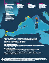
7.14%                          0.04%                       1.6%                         90.05%

              Surface under protection       Surface under               Share of the                 Share of the total
              status                         stronger protection         Mediterranean surface        Mediterranean surface
              179,798 km² / 1,231            (no-go, no-take or          covered by 186 MPAs          under designation
              MPAs and Other Effective       no-fishing zones)           of national status           located in European
              Area-based Conservation                                                                 waters.
              Measures (OECM)
              including*:
              • 186 MPAs of national
               status: 1.60%
              • 898 marine Natura 2000
               sites: 2.37%
              • 3 GFCM Fisheries Restricted
               Areas: 0.62%
              • Pelagos Sanctuary for
               marine mammals: 3.47%
              * The above percentages cannot be
              added because there are overlaps
              between sites and not all sites are
              mentioned.


            THE SYSTEM OF MEDITERRANEAN MARINE

            PROTECTED AREAS IN 2016


            What is a marine protected area?
            Marine protected areas are spaces within the sea designated for the protection of species, habitats and ecosystems which may
            sometimes allow sustainable use of marine resources.

            There are different types of MPAS:
              •  partially protected (some uses are prohibited while others, such as fishing, are authorized and regulated);
              •  strictly protected (all extractive or destructive use is prohibited, save for the needs of science).

            No-take zones are also called “full reserves”; multiple-use (most Mediterranean MPAs) combining partially and strictly
            protected areas according to specific zoning.


            * MAPAMED, the Mediterranean Marine Protected Areas database, has been updated with a new dataset that enriches the data available in 2012, adding sites created prior to 2012 (but not reported then), adding sites
            created since 2012, and recording news designations that were not part of the 2012 assessment (Ramsar sites, World Heritage sites,…).
            Dataset: MPAs: MAPAMED, the database on Sites of interest for the conservation of marine environment in the Mediterranean Sea. MedPAN, UN Environment - MPA - SPA/RAC. October 2016 release.Countries: Natural Earth.
            Admin 0 - Countries. 2016. Disclaimer: the mentions on this map do not necessarily reflect those of MedPAN, UN Environment - MAP - SPA/RAC or their partners..